
Version: 1.2 main index
Introduction
Program Menus
and Controls
Running TaxEdit
Parameter set up
Startup and
Configuration
Program Messages
TaxEdit is used for preparing seismic profile auxiliary data, that is shotpoint to trace relationships, velocities, mutes, locations, horizon picks, side labels and any other data which cannot be stored in the trace file itself.. Version 1.1 of TaxEdit enables legacy data from Lynx's MS-DOS 3S vectorising and processing software to be used with the latest versions of Lynx's seismic programs TracePro and TraceFix.
All the auxiliary data for a given seismic trace file are stored in a trace auxiliary file, with extension .TAX, having the same name as the trace file to which it belongs. Specifrically, the trace auxiliary file offers the following major advantages over holding the data in seismic file or trace headers:-
To create a TAX File, click File|New. From the Open dialogue box, select the trace file with which the TAX file is to be associated. The seismic profile's name will be copied into the global section of the newly created file and a new dialogue box will open for the global parameters to be edited. A TAX file can be created with no corresponding trace file by selecting Cancel in the Open dialogue and continuing with the dialogues which follow.
The main
ToolBar contains a file select button on the left, a group of buttons
for choosing which section from the opened file to edit and a group of editor
buttons which are activated while a section is being editied. A context
sensitive Help button
![]() lies to the
right of the editor buttons. The horizon tool buttons are on the right, with
the currently selected horizon panel farthest right.
lies to the
right of the editor buttons. The horizon tool buttons are on the right, with
the currently selected horizon panel farthest right.
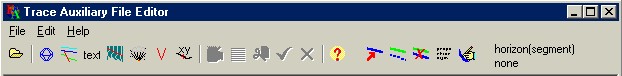
Enables selection of an existing .TAX file for editing., duplicating the File|Open menu.
activates the [global] section editor page, duplicating the Edit|Global menu.
activates the horizon tool buttons and enables editing of the current horizon, if one is selected.
enables data editing of the trace label information.
enables data editing of trace mute start and stop times.
enables data editing of trace or cdp to shotpoint relationships.
invokes the velocity control point edit page.
Data Editing When the data editor is active, the buttons shown below are activated. A grid of cells will be visible. The first row contains column titles or units and each subsequent row contains one record from a TAX file section. The data editor buttons enable individual cells to be edited and records to be inserted or deleted.

The edit mode button will toggle edting of individual cells on or off.
The insert button will insert a new record after the last record currently selected (highlighted)
The delete button will delete a group of one or more highlighted records.
The save button copies the editied data to the TAX file, replacing any existing data. in the current [section]
The cancel button exits from data editing, without replacing the current section.
The Help button provides context sensitive help (this file) for the currently selected control
The main menu has standard File, Edit and Help options
File The main File menu contains the following sub items:-
Open - Enables selection of an existing TAX file for editing
Save - Saves current edits to the opened file (Save As is not implemented)
Import - Import data from various file types into TaxEdit
Export - Export data
New - create a new TAX file from a trace file
Exit - Quit TaxEdit, with prompt to save altered data
Import allows data to be imported to individual sections of the TAX file, from various sources. The formats implemented for a particular segment will be indicated by the file extensions in the "Files of type" drop down menu in the open dialog. Common supported file types are :
XYZ files are column delimited ASCII files, in which data are arranged in columns delimited by tab or space characters. Obviously, the width of any given column must be wide enough to accomodate the largest number of characters that data in that column will have. CSV files (comma separated value files) employ commas or other non alphameric characters to separate the fields within a row. Fields containing one or more delimiter characters must be enclosed in single or double quotation marks, or other specified character. CSV files are particularly useful for importing and exporting to spreadsheets, such as Microsoft Excel. In TAXEDIT, the columns for a given data type will appear by default in the XYZ or CSV file in the same order as they are defined for the .TAX file.
Import horizon data
Horizon data can be imported as TXT or CSV files. In either case, records are of the form
profile,horizon, locator, TZ, [A],[flag]
In a CSV file, the columns are separated by commas. The first record can contain column names - in this version of TaxEdit they will be ignored. In a TXT file there must be at least one blank space between every column. The records for a given horizon must be contiguous.
The use of profile and horizon columns enables the input file to contain mutiple profiles and horizons in a single file. profile must match exactly the corresponding profile name in the TAX file's global parameters. Flag is an optional end of segment indicator, for horizons having discontinuous events.
TZ are time or depth values to be stored in the TAX file, as determined by the Z coordinate type in the horizon's properties.
A is an optional horizon attribute, such as amplitude, reflection quality etc.
The example below shows a horizon "top Creataceous" having four points on the first segement and two on the second. The end segment flag can be omitted for the last segment, or if the horizon has only one segment. The Z values in all cases are zero.
LINE-23,top Cretaceous,0.0,1240.0,0.0
LINE-23,top
Cretaceous,20.0,1247.5,0.0
LINE-23,top
Cretaceous30.0,1256.0,0.0
LINE-23,top Cretaceous,40.0,1264.0,0.0,end
segment
LINE-23,Cretaceous,48.0,1400.0,0.0
LINE-23,Cretaceous,60.0,1460.0,0.0
Import Mutes Imports mute data from a Lynx 3-S .MTE file. The start and stop times in the .mte file are imported into the standard mute horizons, MUTESTART and MUTESTOP.
Import Shotpoints Imports shot-trace relationship data from a Lynx 3-S .SPT file.
The 3-S ASCII file SPT file normally has a filename that is the same as the corresponding trace file name, but with an extension .SPT. For example if the tracefile is MYFILE.TR1 then the shotpoint ascii file would be MYFILE.SPT.
Each line of the file then has a trace number followed by the shotpoint that is associated with that trace. The trace number must be an whole number with no decimal point whilst the shotpoint number must be a number with a decimal point. The trace numbers must be in the correct order. The trace number and shotpoint number should be separated by spaces. The file should be produced by a text editor or word processor working in ASCII mode. It should not contain any other information or numbers other than those specified.
Example:
1 25.0
20 30.0
40 35.0
54 40.0
Import trace labels Import trace labels from a Lynx 3-S .LBL file
Import Velocities Import velocity data from a Lynx 3-S .VEL file, or ASCII CSV file.
When importing from Lynx VEL files, generated in the 3S MIGRATE program, note that the velocity table for a given point on the profile is always referenced by trace, although the VEL format allows shotpoint numbers to be enetered.
The CSV file for velocity import should have records of the form
profile,locator,time,VRMS
profile is the name of the seismic profile (line) appearing in the global "Name of profile" field and must match including case.
locator is the position along the profile, as shotpoint, trace number, CDP or distance. Before loading the file, change the global "profile coordinate type" to match the the type of locator.
time is the two-way time in appropriate units and
VRMS is the root mean square or stacking velocity of the point.
Import XY coords Import XY coordinate data from a Lynx .LOC file, csv file or column delimited text file. A .LOC file is an ASCII UKOOA format seismic location file, which can be generated using Lynx's LOCDIG or associated 3S programs.
The other formats require that the data records be ordered as locator X Y. For example, in an xyz file the three columns refer to locator, X and Y. Locator is the position along the profile, as shotpoint, trace number, CDP or distance.
Export File menu sub-item, for exporting TAX file data to various file types
New File menu sub-item. Create a new TAX file
Edit - select a TAX file section to edit.
Global select and edit global TAX file properties.
Labels select and edit trace labels
Shotpoints section select and edit
Velocities section select and edit
X-Y coords section select and edit
Index get help index (this file)
Memo1 The display of the "raw" TAX file contents.
When a [section] is selected for editing, a string grid editor display will appear, something like this:-
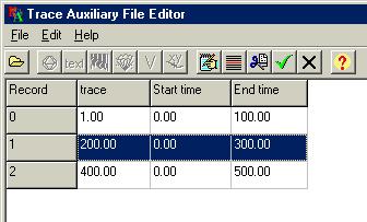
The actual appearance will depend on which section is being edited, but the display will always contain a heading, with three or more columns. The first column shows the record number of the entries in the section. The second column shows the keys and the third and subsequent columns show the values associated with the keys. For example, the actual data for the display shown above would appear in the underlying TAX file [mute] section as
[mute]
coordtype=trace
1.0=0.0,100.0
200.0=0.0,300.0
400.0=0.0,500.0
To edit individual values, click the edit mode button
![]() . This will
allow individual cells to be selected and edited.
. This will
allow individual cells to be selected and edited.
Changing a [section]'s profile coordinate type
In the above
example, the mute start and end times are located on the corresponding seismic
profile by trace number..If the mutes are required to be relative to shotpoint
numbers, click on the heading of the column, over title "Start time". A popup
menu will appear which enables alternative coordinate types to be selected,
e.g. shotpoint, cdp, distance etc. The current setting will be checked on the
popup menu. If the coordtype for the [section] is the same as the global
coordtype, it need not appear in the [section] itself.
Changing a [section]'s units
By clicking on the column
headings to the right of the second column, a popup menu will appear which
enables the appropriate units to be selected for the values in the column. In
the mute example above, values are in time, so the popup menu will present a
choice of time units as microsec, msec, sec or samples, for the corresponding
values in the third and fourth columns.
IMPORTANT. Changing the units in this way does not change the actual values in the [section]. The units key merely indicates what units are being used.
TaxEdit has parameter edit pages as below
page index
page : Global Settings
page : RMS Velocity Control Point
Global settings apply to the whole .TAX file, unless they are overridden locally in a section.
Name of profile : (type string) The seismic profile's name (line name). When a new .TAX file is created with the File|New menu, this name will be taken from the seismic trace file specified at that time. This name is used when importing data from external files which may contain data pertaining to more than one profile.
Profile coord type : (type option, none,
trace, shotpoint, CDP, distance ) The default coordinate relation used to
locate TAX file information with seismic traces. For example, setting
coordtype=shotpoint indicates that by default, information will be located by
shotpoint number and will appear in the form
shotpoint number
=information
XY Units : (type option, none, feet,
metres, km, cm, decdeg, decsec, traces,) The default units used for X-Y
information
Depth Units : (type option, none, feet,
metres) The default units used for depth information
Time Units : (type option, none, microsec,
msec, sec, samples ) The default units used for time information.
The velocity control point editor displays velocities in the form that they appear on the top of a seismic section. The velocity units are determined by the depth zunits and time units set in the [global] section of the TAX file. Note that for most purposes, e.g. mutes or horizon picks, time units are milliseconds, indicated by tunits=msec. In the case of velocities, time units are nearly always seconds, in which case tunits=secs should appear in the [velocity] section.
This point active :
(type option,
Yes, No ) Currently ignored. This has been retained for backward compatibility
with older Lynx 3-S velocity formats.
Trace number : (type long integer, limits 1 to 32000) The trace number for this velocity point, when the coordtype is trace. Ignored if coordtype is set to anything other than trace.
ShotPoint number : (type single, limits -1000000.0 to 1000000.0)
The shotpoint number for this velocity point, when the coordtype is shotpoint.
Ignored if coordtype is set to anything other than shotpoint.
X : (type single, limits -1.e+7 to 1.e+7) Currently ignored (The
X-coordinate for this velocity point)
Y : (type single, limits
-1.e+7 to 1.e+7) Currently ignored (The Y-coordinate for this velocity point)
(type long integer,
limits 0 to 20000)
Velocity data points are entered as time velocity
pairs
The export output format page is used to determine the characteristics of ouput files generated under the main menu File|Export menu..
Output file type (type option, text,
delimited, Shape) determines the format of the file to which data are to be
exported.
text - export to column delimited text file
delimited - export
to text file with delimiter characters to separate the columns
Shape -
export to ESRI Shape file (not implemented)
column width
(type long integer, limits 2 to 99) If the
output file type is text, this determines the column width used, in
characters
separate fields by (type option,
comma, hash, semicolon) where output file type is delimited, the
delimiter used to separate data fields in each output line,.
decimal places (type long integer,
limits 0 to 12) the number of decimal places after the decimal point for each
output value. Where fixed column width is used (output file type is
text), this should be large enough to accomodate the full range of
expected data values.
X increment type (type option,
datapoints, regular ) determines the X interval at which data points are
output.
datapoints - output every data point
regular - output data points
at a regular interval determined by the output X increment below.
output X increment (type single, limits 0.0 to 1.0E10) determines the X interval at which data points are output.
output endpoints (type option, Yes, No) determines whether the first and last data point of each line part is output under X increment type regular, if they do not fall on a point whose X coordinate is divisible exactly by the X increment.
Shape files
ESRI Shape files are used as a convenient way for importing and exporting seismic location and horizon data for use in GIS projects.
When using ESRI shape files as horizons, the follwing points should be considered :-
There is no standard way of using Shape files to store seismic horizon information. Shape files are "dimensionless" i.e. the file itself does not specify what coordinate units are used in the file. Horizon data can be imported from either 2-D or 3-D shape files, of type "polyline", where each polyline record in the shape file represents a single horizon on a single profile.
2-D shape file. A shape file having only X-Y coordinates, representing a vertical section. X represents a horizontal position, e.g. shotpoint, distance, CDP or trace and Y represents the vertical depth or time. It is assumed the
3-D shape file. A shape file having X-Y-Z coordinates, where X-Y represents a position on the surface and Z the corresponding vertical depth or time.
All Lynx Exploration Archivist application programs have a corresponding .INI file in the Lynx system directory. The [startup] section contains program constants which can be edited manually, or through the LEAConfig application.
3S velocity file read error a read error ocurred while attempting to load a 3-S velocity file.
CSV velocity file read error a read error ocurred while attempting to load a 3-S velocity file. Possible error return codes are
error - location key was non-numeric an attempt was made to load or save a location key which was non-numeric. The location key is a "surface location" on a seismic profile, i.e. shotpoint, CDP, distance or trace number
location key is blank an attempt was made to load or save a record which had a blank location key. The location key is a "surface location" on a seismic profile, i.e. shotpoint, CDP, distance or trace number.